|
Cape Henry Overview
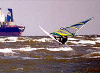
Chick's Beach is a popular sailing site for sailors of every skill level depending on how strong the wind and from which direction the wind is blowing... especially close to shore. All directions blow strong except south and southwest (the only directions that do NOT face the open Chesapeake to the north and west, and the open Atlantic to the east).
See details at http://www.windvisions.com/cape_henry.html
Kiteboarders: Check First Landing State Park (Lynnhaven Pier link) or Virginia Beach Oceanfront
|
 |
Local Expert?  Edit this Page! Edit this Page!
Regional Directory
|
|
Shops,
Schools,
Clubs,
Events,
Food,
Lodging,
More,
|
|
 |
|
|
 |
|
Maps & Directions
Chick's Beach is a few miles east of Route 13 at the first exit over the Chesapeake Bay Bridge/Tunnel. Exit onto Route 60 east (Shore Drive). The sailing site is located adjacent to the Duck-Inn Restaurant on the east side of the Lynnhaven Inlet.
|
|
|
Sensor Notes
The sensors, relocated in September 1996, are situated on the Pilot Tower at Cape Henry(Fort Story), a few miles to the east of Lynnhaven Inlet in Virginia Beach.
|
|
|
