• CLASSIC IKITESURF
    Classic myiKitesurfClassic Wind & Weather maps and graphs
Hello Guest
 • 

Classic iKitesurf  
Grab the iKitesurf Mobile App & Sign On to the New iKitesurf Website
Hi guest · Get your free membership now · Log In ·
Stonewall Bank Buoy
 > Current Wind Graph
 > Meteogram
 > Onsite Report
 > Wind Yesterday
 > Last 7 Days
 > Wind Archive
 > Local Info
 > Sensor Notes
 > Wind Alert
OR - coast

Human Forecasts
 > Daily Briefing

Real-Time Data
 > Dynamic Map
 > Wind Obs Map
 > Radar + Satellite Map
 > Wind Obs Summary

Computer Forecasts
 > Model Tables
 > Wind Vector Fx Map
 > Wind FlowViz Fx Map

More Maps

Other Resources

Watches/Warnings
>None Active


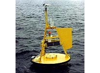
This buoy is located at 44.62N 124.53W making it a "nearshore" indicator of swell and wind data. It is stationed approx. 20 miles off the Oregon Coast, due west of Newport. Also referenced as "Stonewall Banks", it is highly useful for determining what type of beach conditions one will encounter in the short term.
Local Expert? edit Edit this Page!
Shops, Schools, Clubs, Events, Food, Lodging, More,

Data from this station is courtesy of NOAA's National Data Buoy Center.

© Copyright 2024 WeatherFlow, Inc · Contact Us ·