|
Sherman Island Overview
Known as The Delta, or Sherman Island, or Rio, the entrance to the Sacramento River Delta, near the town of Rio Vista, is the most popular sailing site in the Bay Area for sailors looking for strong warm wind in the summer. If the Bay is fog-shrouded and the Golden Gate lost to view, think Rio Daze and head to the Delta for warm air and hot sailing! On an ebb tide Sherman offers steep 1-3 foot chop swell with great starboard ramps. The reaches are short so the action is intense and in your face. Great place to watch hotshots. On floods and lighter wind days there is easy slalom sailing.
Windsurfing on Sherman Island is possible due to the continuous hard work of the RVWA - the Rio Vista Windsurfing Association. RVWA maintains most of the sailing sites (sand bagging, portapotties,
cleanups), works with the County Parks and the State Parks to provide access, leases land for sailing sites The Sign & The Access, and funds and builds new spots such as Windy Cove. They are very deserving of your support - please consider joining them. More info.
The wind is side-onshore at most of the sailing sites. The SW to WSW winds blow here in several different patterns. Sometimes it blows all night and then blows all day with a mid-day fade in between strong wind sessions. Other times it blows at night and early morning then dies more or less completely and then comes back up again in the late afternoon. Less common is a pattern where it is light in the very early morning then dies and then blows late in the afternoon.
There are spring weather patterns where a cold North wind blows in the morning and then dies. In these winds the best launches are Windy Cove, Glass Beach, Jackson Hole, Sand Bar, and Fishermen's.
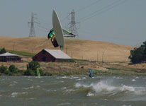
For bump and jump sailing the ebb is the time and the Powerlines is one of the most popular places. For less confident sailors, Team Rio beach has on-shore winds and weak current near shore. On those days when even big guys are on 3.5 sails head North past the town of Rio Vista and go into Sand Bar Park. It is less windy there and is always a better place for beginners when the current is light.
Team Rio Beach has a tiny sandy beach for launching, tules for stashing gear, and a grassy/sandy rigging area. The Access has a tiny sandy beach and the sites along the river have plastic sand bags over rip-rap rocks for launching and you can rig on weeds, gravel, or carpet. Powerlines and The Sign / Cable Crossing offer plastic sand bags over rip-rap with rigging on mown weeds. The swell is probably the best on the river at The Sign / Cable Crossing.
Glass Beach close to the town of Rio Vista was once the most popular site but it is seldom sailed these day. This beach has a wide beach but pilings and broken glass make this a bootie-only launch.
All the sailing areas are crowded near the launch but if you go just upwind or downwind of the crowd you can find your own personal water space.
The fresh water is much warmer than the Bay. Water quality is extremely poor with water muddied by soil, manure, and agricultural runoff. The currents are strong at all sites except near the Team Rio and Access beaches. If you are not good at staying upwind be aware of what's going on when sailing on a flood. If you can not get back to your launch site go in at the next one down current. Once you are swept past all the launch sites it can be hard to exit the water and you will have to carry your gear on a road with fast traffic. Be especially careful in sailing a ebb at the Access since if the wind dies you can be carried into vast and unpopulated Suisun Bay.
Parking at the Access is extremely crowded and many sailors spend the night here. Powerlines, The Sign / Cable Crossing, Windy Cove, Team Rio Beach, and Glass Beach have lots of parking.
Sherman Island is not a particularly scenic location -- except in a mellow bucolic sense -- but still is has something to offer the family. It is a good place for roadside or parking lot camping right at some of the launch sites. There is a great family campground at Brannan Island State Park across from Windy Cove. At the Access there is a good sense of community and the traffic is slow. At the Powerlines there is great viewing but the traffic is a bit too fast for comfort if you have kids. Porta-poties are located at most sites but you won't find much in the way of drinking water or food unless you bring it yourself.
|
 |
Local Expert?  Edit this Page! Edit this Page!
Regional Directory
|
|
Shops,
Schools,
Clubs,
Events,
Food,
Lodging,
More,
|
|
 |
|
| Season: |
Peak June-Aug |
|
| Water: |
Warm, muddy |
|
| Ability Level: |
Beginner-Adv. |
|
| Familiness: |
Watching, camping, hanging out |
|
| Parking: |
Crowded some sites |
|
| Launch: |
Beach or sand bags or rocks |
|
|
 |
|
Maps & Directions
 From the Peninsula Go across the San Mateo Bridge on Hwy. 92 and go North on Hwy. 880. Continue north on Hwy 880 until you reach San Lorenzo. There take the 580 off ramp and go east towards Dublin. Near Dublin go North on Hwy. 680 Stay on Hwy. 680 until you come into Walnut Creek. At Walnut Creek take Hwy. 242 going towards Concord. Continue past Concord on Hwy 242 When you reach Hwy. 4 merge going East towards Antioch Continue on Hwy 4 going past Antioch. Merges with Hwy. 160 and cross bridge Continue north on Hwy. 160 across Sherman Island. Then you have two options: If you want to go to the Powerlines or the Access: As you approach the water look for Sherman Island Rd. going left. You can launch at the Powerlines or continue to the Access at the end the road. Remember the wind can be stronger at the Access or at the Powertlines so check out both sites if the wind is light
If you are going to Windy Cove, Jungle, Sand Bar etc: Continue on north on Hwy. 160 and cross the bridge and look for the left turn into Windy Cove. Continue on Hwy 160 to Glass Beach and Sand Bar.
From the East Bay: Go north on Hwy. 580/80 Near the racetrack just north of the Berkeley Marina get in the right lane and continue north on Hwy. 80 Near the town of Hercules turn east on Hwy. 4 Continue on Hwy 4 going past Antioch. Hwy 4 merges with Hwy. 160 going north crossing the bridge Then follow the instructions above
From San Francisco and Marin County Cross the San Rafael Richmond Bridge. Then take the rarely used Richmond Parkway off ramp. Head north for several miles until it merges with Hwy. 80 going north. Near the town of Hercules turn east on Hwy. 4 Then follow the instructions above.
From Sonoma County Go south on Hwy 101 Past Novato take the Hwy 37 off ramp going east. Continue on Hwy 37 as it passes through Vallejo and turns into Marine World Parkway Then merge with Hwy 80 going north. Go north on Hwy 80 for about 15 miles Passing the Cordella turn off start looking ahead for Hwy 12 At Hwy 12 take the off ramp and head east for about 20 miles in strong wind. A Rio Vista cross the bridge over the Sacramento River. (don’t worry if there is not much wind here) Just across the bridge turn right onto Hwy 160 Go several miles south. Just before the next bridge check out the Windy Cove sailing site. To get to the Powerlines and Access sailing sites continue on Hwy 160 About 2 miles past the bridge the road will turn left and leave the river. JUST as it makes this turn go right on Sherman Island Rd to the sailing sites.
From the Peninsula Go across the San Mateo Bridge on Hwy. 92 and go North on Hwy. 880. Continue north on Hwy 880 until you reach San Lorenzo. There take the 580 off ramp and go east towards Dublin. Near Dublin go North on Hwy. 680 Stay on Hwy. 680 until you come into Walnut Creek. At Walnut Creek take Hwy. 242 going towards Concord. Continue past Concord on Hwy 242 When you reach Hwy. 4 merge going East towards Antioch Continue on Hwy 4 going past Antioch. Merges with Hwy. 160 and cross bridge Continue north on Hwy. 160 across Sherman Island. Then you have two options: If you want to go to the Powerlines or the Access: As you approach the water look for Sherman Island Rd. going left. You can launch at the Powerlines or continue to the Access at the end the road. Remember the wind can be stronger at the Access or at the Powertlines so check out both sites if the wind is light
If you are going to Windy Cove, Jungle, Sand Bar etc: Continue on north on Hwy. 160 and cross the bridge and look for the left turn into Windy Cove. Continue on Hwy 160 to Glass Beach and Sand Bar.
From the East Bay: Go north on Hwy. 580/80 Near the racetrack just north of the Berkeley Marina get in the right lane and continue north on Hwy. 80 Near the town of Hercules turn east on Hwy. 4 Continue on Hwy 4 going past Antioch. Hwy 4 merges with Hwy. 160 going north crossing the bridge Then follow the instructions above
From San Francisco and Marin County Cross the San Rafael Richmond Bridge. Then take the rarely used Richmond Parkway off ramp. Head north for several miles until it merges with Hwy. 80 going north. Near the town of Hercules turn east on Hwy. 4 Then follow the instructions above.
From Sonoma County Go south on Hwy 101 Past Novato take the Hwy 37 off ramp going east. Continue on Hwy 37 as it passes through Vallejo and turns into Marine World Parkway Then merge with Hwy 80 going north. Go north on Hwy 80 for about 15 miles Passing the Cordella turn off start looking ahead for Hwy 12 At Hwy 12 take the off ramp and head east for about 20 miles in strong wind. A Rio Vista cross the bridge over the Sacramento River. (don’t worry if there is not much wind here) Just across the bridge turn right onto Hwy 160 Go several miles south. Just before the next bridge check out the Windy Cove sailing site. To get to the Powerlines and Access sailing sites continue on Hwy 160 About 2 miles past the bridge the road will turn left and leave the river. JUST as it makes this turn go right on Sherman Island Rd to the sailing sites.
|
|
|
Sensor Notes
The sensor is located at Powerlines. When the wind is more south the wind will be stronger at the Access than indicated by the sensor. When the reading is more West the Powerlines & Access are of the same wind strength. On WSW wind, the sensor will generally read low. As with all sensors, personal experience will help determine what a specific reported windspeed number means in terms of what sail size to rig. The more North in the reading the better WINDY COVE will be and the lighter the sensor will read. The wind can be much better at one end of the island than the other so it is always worth driving all the way to the Access. It is useful to watch the Travis AFB sensor to help judge the wind. Be sure to watch your pager while driving since it often dies mid-day.
Note: this sensor uses older technology and sometimes shows "lite" when in fact it is windy. When in doubt, trust the "Sherman M14" sensor for more accurate wind reports.
|
|
|
