|
Chapin Overview
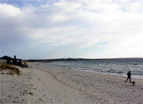
This is where you'll find the strongest winds, and by New England standards, some huge swells and waves. The nearest point of land north is somewhere in Maine so we're talking one amazing fetch. Chapin is an excellent beach to take advantage of these conditions during northerlies and northeasterlies: the launch faces northwest so the waves break further from the shore. This allows you to build some speed and thread your way out of the break zone. Although waves are always present, best sailing is three hours either side of high tide; Chapin is sailable at low tide, but it's a LONG walk to the water... or back to the parking lot. During nor'westerlies, Corporation Beach might be an easier launch, but Chapin will probably still be the windier location. Wave sailors may wish to stick with Corporation Beach all the time since this is where the biggest waves may be found. However, unlike Chapin, both the waves and wind are onshore, especially in due northerlies. Therefore, you must point up into the wind while attempting to get through the break zone -- not fun. Nor'westerly winds are probably the best in terms of launching at Corporation. Finally, watch out for the many submerged rocks and do not sail to the west of the breakwater where the number of submerged rocks represents a real hazard. This area of Cape Cod is under constant siege by damaging storms. More effective at retaining the shoreline than man's cement and boulder placement is the often overlooked and seemingly insignificant Dune Grass. This grass is critical to maintaining the shoreline. However, as tough as it is against the elements, it quickly dies when trod upon. So please be eco-friendly by staying off the Dune Grass.
$15 fee in-season Memorial Day to Labor Day (small lot-fills fast)
|
 |
Local Expert?  Edit this Page! Edit this Page!
Regional Directory
|
|
Shops,
Schools,
Clubs,
Events,
Food,
Lodging,
More,
|
|
 |
|
| Season: |
April-October |
|
| Ability Level: |
Beginner-Advanced |
|
| Familiness: |
good family beach |
|
| Launch: |
sandy beach |
|
|
 |
|
Maps & Directions
For Chapin, take x8 of Route 6E and go north on Union Street. Turn right on 6A and head east for three miles. Turn left on New Boston Road. (Chapin Beach is just past the Aqua Cultural Research facility so watch for their signs.) Go 1/4 mile and trunk right on Beach Street. At the fork, take the middle road (Taunton Avenue). Taunton takes a sharp left at the water and becomes Dr. Bottero Road. The next fork is ACR's driveway, bear right and continue to beach. For Corporation, follow above directions until heading east on 6A. Turn left on Corporation Road (by an antique store). The beach is at the end of the road.
|
|
|
Sensor Notes
The sensor is atop a warehouse within sight of the beach. Both the launch and sensor are at the outer edge of a large salt marsh, so they have a clear fetch in all directions. This makes for some surprisingly strong southerly (offshore) winds. Onshore and sideshore winds at Corporation Beach are similar to those at Chapin. However, given that Corporation Beach has a bluff behind it rather than a salt marsh, offshore winds (southerlies) are to be avoided at Corporation.
|
|
|
