|
Marrowstone Island Overview
In the spring through the fall strong southerly winds can develop as storm fronts approach the coast. Marrowstone Island benefits from the Olympic Mountain rain shadow and will often be dry and overcast while the rest of Puget Sound is getting drenched.
Conditions at Marrowstone Point are strongly affected by tidal flow. Sailing can be difficult in strong outgoing tides. However, there are several other good sailing locations on Marrowstone Island including Oak Bay and East Beach when conditions dictate you should go elsewhere.
Marrowstone Point has lots of parking, an outdoor restroom and sheltered wind breaks. People attempting to sail here should be proficient jibing in rough windy conditions and have “pointing” skills.
|
 |
Local Expert?  Edit this Page! Edit this Page!
Regional Directory
|
|
Shops,
Schools,
Clubs,
Events,
Food,
Lodging,
More,
|
|
 |
|
| Season: |
Spring / Fall |
|
| Water: |
strongly tidal effected, rough w/ closely spaced swells |
|
| Ability Level: |
intermediate to advanced |
|
| Familiness: |
good parking, bathroom, somewhat exposed |
|
| Parking: |
ample |
|
| Launch: |
sand and small, round rock |
|
|
 |
|
Maps & Directions
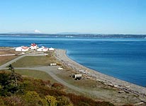
Marrowstone Point is located on Marrowstone Island, approximately 38 miles northwest of Seattle and just south of where Admiralty Inlet meets the east entrance to the Straits of Juan De Fuca. It is a 39 mile drive north from the Hood Canal Floating Bridge. Follow the signs to Fort Flagler State Park.
|
|
|
Sensor Notes
This sensor is positioned on a single story building adjacent to the main launch area. It has excellent, clean fetch from nearly 360 degrees and should provide a rather solid indicator of local winds along the Point. There is a small bluff located due WEST of the site which could cause readings to bounce around a bit but should not present a large scale problem.
|
|
|
