|
Jones Beach Overview
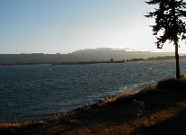
Jones Beach is located just north and west of the Portland/Vancouver along the Columbia River. The coastal range of mountains (which seperates the Pacific Ocean and the I-5 corridor) has a tight gap that strongly funnels onshore gradients. When the barometer drops in the Portland area and remains steady at Astoria (look for a difference of at least .07), Jones Beach becomes sailable. Quite often on summer days, a slow moving mass of cool ocean air will sit on the outside of the coastal range and the interior valleys will stay clear in turn creating very strong westerly winds. The channel on the north side of the river was nicknamed "Nuclear Alley" years ago by sailors who would often launch from the Oregon side and tack upwind into the channel
between Puget Island and the Washington shoreline where sails are usually one size smaller.
Typical sail sizes for Jones beach are 5.0 to 5.5 in the north channel and 6.0 on the Oregon side. Good days can see winds near 30 with sail sizes in the 3.x range. The river is quite wide at this point, much more expansive than the Gorge.
The river can be sailed on either an incoming or an outgoing tide, but an
incoming tide requires a good pointer fin. The swells are best in the Nuclear Alley channel on an outgoing tide when the winds get above 20 mph. The swells are not large by Gorge standards, but they provide for some fun chop hopping.
The wind waves and shore echo on the Oregon side of the river set up a
washboard effect that is uncomfortable at times and lacks any rhythm.
The Oregon launch includes paved parking, large sandy beaches, and
portapotties. There is no running water, and the beach area is unpatrolled. Camp at your own risk.
The Washington side has no facilities. All parking and rigging is on private property. There is only parking for about half a dozen cars. The state has recently excavated to reduce parking at the site, and it appears they would like to discourage launching from here. The advantage is that you are able to launch very near the best wind at the entrance of Nuclear Alley. Be very careful crossing the highway as motorists are often distracted by the action on the river. Whatever you do, clean up after yourself. There are no portapotties here so plan ahead!
Local groups in the Lower Columbia area have talked for years about creating a waterfront park on Puget Island with a lauch site in the middle of Nuclear Alley. With the added positive support and feedback from the
windsurfing community, this continues to be a possibility in the future.
|
 |
Local Expert?  Edit this Page! Edit this Page!
Regional Directory
|
|
Shops,
Schools,
Clubs,
Events,
Food,
Lodging,
More,
|
|
 |
|
| Season: |
May to October |
|
| Water: |
chop, small swells |
|
| Ability Level: |
intermediate |
|
| Familiness: |
no facilities |
|
| Parking: |
sparse |
|
| Launch: |
gravel, near highway |
|
|
 |
|
|
Sensor Notes
The sensor is located on the WA side at Harry's Pt. It is mounted in a tree approximately 30 ft in the air above the water. Situated about 1/4 mile down the highway from the main launch area, it should provide a fairly representative reading of actual conditions on the water. But always expect average speeds in the channel to be higher than reported and often much closer to the gust value.
|
|
|
