• CLASSIC IKITESURF
    Classic myiKitesurfClassic Wind & Weather maps and graphs
Hello Guest
 • 

Classic iKitesurf  
Grab the iKitesurf Mobile App & Sign On to the New iKitesurf Website
Hi guest · Get your free membership now · Log In ·
La Perouse Bank Buoy
 > Current Wind Graph
 > Meteogram
 > Onsite Report
 > Wind Yesterday
 > Last 7 Days
 > Wind Archive
 > Local Info
 > Sensor Notes
 > Wind Alert
BC- British Columbia

Human Forecasts
 > Daily Briefing
 > Forecast Blog

Real-Time Data
 > Dynamic Map
 > Wind Obs Map
 > Radar + Satellite Map
 > Wind Obs Summary

Computer Forecasts
 > Model Tables
 > Wind Vector Fx Map
 > Wind FlowViz Fx Map

More Maps

Other Resources

Watches/Warnings
>None Active


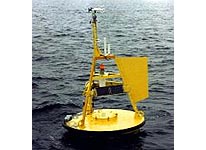
This buoy is located at 48.84N 126W making it a "nearshore" indicator of swell and wind data. It is stationed approx. 15 miles off the B.C. Coast, due west from the Straits of Juan de Fuca. It is highly useful for determining what type wind and swell patterns will set up on beaches in the short term.
Local Expert? edit Edit this Page!
Shops, Schools, Clubs, Events, Food, Lodging, More,

Data from this station is courtesy of the National Data Buoy Center.

© Copyright 2024 WeatherFlow, Inc · Contact Us ·