|
Florence Overview
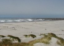
The Florence area has a wide variety of sailing locations which offer some truly epic wavesailing conditions during the summer months of June through September. The main sailing spot in this area lies at the end of the South Jetty where the Siuslaw empties into the ocean. On busy weekends during peak season, as many as 60-80 sailors will be out in the cold, churning Oregon surfzone. Its popularity is due to the protective jetty wall which sticks out to sea (approximately 1/2 mile) shielding the launch area from the full brunt of the mighty Pacific. What isn't so popular about this area are the facilities. While restrooms are available if you pay the $5 park fee, that's about all you will find in the immediate area. The South Jetty is infamous for being quite unpleasant with members of your party who are not sailing. For small children, there are better areas along the coast to spend the day. As for wind/wave conditions, expect to find lots of high-quality wavesailing days along this very windy stretch of sandy beached coastline. Typical sail size for the South Jetty is around 4.7 m to 5.3 m with waves ranging from 3-4 ft. up to mast high plus. This spot can handle quite a large wave and is often the only choice during heavy swell periods.
Another sailing option for those concerned with wave size is to sail just inside the jetty or the Rock Dock (the crab pier that extends into the river near the the South Jetty) in the Siuslaw. The Rock Dock can be like a mini Gorge, with opposing current to wind ( on North wind and outgoing tide)can really be cool. There is also a protected "beach" by the water with little wind that your family might realy enjoy.... Little sand blast at the Rock Dock. Best if about 1 hour after high tide and espesially good if the high tide to low tide is low.... (4.5 ft high 2.0 low) Be sure to check out the tidal conditions and try to time your sailing around slack periods, a clean wave is sailable between the jetty walls during 15+ ft. swells and strong NW winds. nobody sails in between the jetties, it too weird...watch for sea lion (very large) and california seals (cool) Also be sure to check out Neptune Beach located just north of Sea Lion Caves off HWY 101. With more rocks in the downwind zone, this spot requires slightly more sailing skill - you need to return to the same spot you started at - but has an even higher quality wave in the 6-8 ft. range
|
 |
Local Expert?  Edit this Page! Edit this Page!
Regional Directory
|
|
Shops,
Schools,
Clubs,
Events,
Food,
Lodging,
More,
|
|
 |
|
| Season: |
Best conditions June through September. |
|
|
 |
|
Maps & Directions
A solid four hour drive from Hood River, this spot is often well worth the effort. Head south on I-5 from Portland through Salem and starting looking to exit just prior to entering Eugene. Take exit 195A and proceed west on Beltline Rd. Continue on Beltline Rd. it will turn toward the south and end at RTE 126 (10 miles), this will go from 4 lane highway down to a 2 lane road right before the RTE 126 junction. Turn right (west) towards Veneta and continue west on RTE 126 all the way to the intersection w/ RTE 36 at the Siuslaw River (Mapleton). Turn left (south) on RTE 126 and continue westward towards Florence. After 25 minutes of RTE 126 or so, you will come into the town of Florence. To reach the South Jetty, turn left (south) on HWY 101 and drive just over the Siuslaw River Bridge. Just at the top of the hill, turn right into the National Dunes Recreational Area Park. Proceed straight another 3 miles to the end of the jetty, use your best judgement when parking - it will be a costly trip if you have to call a tow truck.
|
|
|
Sensor Notes
The sensor is located approximately 1.5 miles north of the north jetty. Located on the side of a beachfront home with no neighbor to the north, this site will yield very high quality readings. Remember that winds on the inside of the south jetty will probably be a few knots less. It would be possible to sail directly in front of the sensor site - for information on local house rentals contact http://www.whaleswatch.com.
|
|
|
