|
Doug's Beach Overview
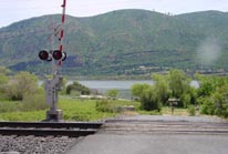
Doug's Beach, named after it's pioneer, has been a long focused upon spot in the Columbia Gorge. Well known for it's nuclear late evening summer performances, Doug's can host a number of ability levels. During the summer months, the gradually sloping Washington river bottom allow those still perfecting their highwind waterstarts some room to work. While in the center of the river, especially off the main point, some of the world's best highwind sailors put on a show. This area also works exclusively with a west wind, best from May to September. Expert sailors will find deep, well spaced swells rolling through in the 6-8 ft range on 3.5m to 4.0m (30-40 mph) days. Ramps set up mainly starboard due to predominant northerly wind angle. Good launch area w/ picnic tables, portapotties and a recently added railroad crossing.
|
 |
Local Expert?  Edit this Page! Edit this Page!
Regional Directory
|
|
Shops,
Schools,
Clubs,
Events,
Food,
Lodging,
More,
|
|
 |
|
| Season: |
Best: April-Oct. |
|
| Water: |
med-lrg swells |
|
| Ability Level: |
advanced/jumps |
|
| Familiness: |
portapotties, nice grassy beach, fast HWY traffic, railroad tracks |
|
| Parking: |
On south side of Hwy 14. Frequently fills up. State Parks pass req'd.. |
|
| Launch: |
sandy |
|
|
 |
|
Maps & Directions
Directions from the Portland/Seattle area are to drive east on I-84 until you reach Hood River. Take the 3rd Hood River exit # 64 and turn left (north) back under the freeway towards the river. After the stop sign, proceed straight across the Hood River Tollbridge (75 cent toll fee) and into Washington. At the end of the bridge, take a right turn onto HWY 14 and drive into Bingen. Continue straight on HWY 14 for about 15 miles through the town of Lyle and begin looking for the parking area after the 1st tunnel you encounter. A large parking area is provided with a single railroad crossing area at the east end. Wash. State Parks parking pass no longer required.
|
|
|
Sensor Notes
The sensor is located approximately 1 mile east of the launch site on the Washington side. Stationed on top of a private home, it is about 100 feet above river level and some 400 feet inland. Winds averaging 20 mph or above generally indicate 4.7 sailing conditions.
|
|
|
